Dashboard Did You Know? Dashboard Mapping Tools
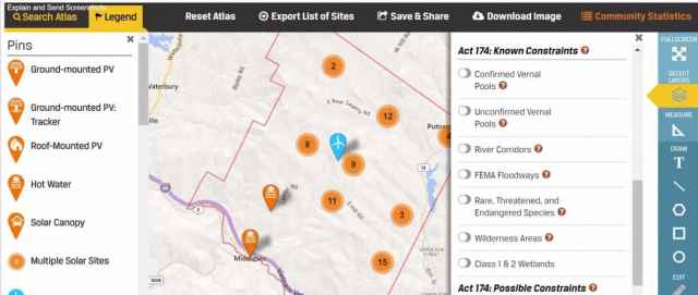
The Dashboard Energy Atlas has parcel maps and 3-phase lines available as layers to use in energy planning as well as all Act 174 “known” and “possible” constraints. Visit the Energy Atlas, select your community and click on the “select layers” icon in the right-hand tool bar of the map. Under ENERGY you will see three-phase lines. Switch it on and voila! Three-phase Lines! Scroll down a bit further and you will see Act 174: Known Constraints. We hope these layers are helpful in your town and RPC planning.
Act 174 (Energy Planning): Known Constraints
- Confirmed Vernal Pools
- Unconfirmed Vernal Pools
- River Corridors
- FEMA Floodways
- Rare, Threatened, and Endangered Species
- Wilderness Areas
- Class 1 & 2 Wetlands
Act 174 (Energy Planning): Possible Constraints
- Agricultural Soils
- Act 250 Agricultural Soil Mitigation Areas
- FEMA Special Flood Hazard Areas
- Protected Lands
- Deer Wintering Areas
- Forest Blocks
- Hydric Soils
Additional Layers
- Vermont Parcels
- Lakes & Ponds
- Recreation Sites
- Trails
Toggle on and off various layers. Layers include parcel maps and all Act 174 Constraints.